Across modern technology landscapes, problems are no longer confined to isolated systems or datasets. They stretch across physical environments, influenced by where things happen and how they interact within that space. Decisions that once relied purely on numbers now depend on understanding location, movement, and spatial relationships that shape real-world outcomes. In the absence of this, even the most advanced systems can miss critical context.
What’s driving this is the growing realization that location-aware thinking adds precision to complex problem-solving. Patterns become clearer when mapped. Relationships become actionable when tied to geography. Whether it’s managing infrastructure, tracking environmental change, or coordinating large-scale operations, geospatial thinking brings structure to challenges that would otherwise remain fragmented.
Rising Demand for Spatial Expertise
With the expansion of geospatial datasets, the challenge no longer lies in collecting information but in making sense of it. Spatial data carries multiple layers, including coordinates, patterns, and relationships that require careful interpretation. Without the right expertise, this information remains underutilized, limiting its potential to influence decision-making.
Given this, advanced education, like a master’s, plays a defining role. A GIS master’s degree equips professionals with the ability to analyze, model, and apply spatial data across real-world systems. Programs such as the one offered by Northwest Missouri State University provide structured training in handling complex datasets, integrating mapping technologies, and applying insights in operational environments. This preparation allows professionals to move beyond surface-level analysis and contribute meaningfully to industries that depend on accurate spatial interpretation.
Disaster Response Through Real-Time Mapping
During emergencies, timing and accuracy determine the effectiveness of response efforts. Real-time geospatial mapping provides a continuously updated view of conditions, allowing teams to track events as they evolve. This dynamic perspective supports faster decision-making and helps coordinate multiple response units across affected areas.
In large-scale incidents such as hurricanes or wildfires, mapping tools highlight impacted zones, safe routes, and areas requiring immediate attention. Emergency teams rely on this information to allocate resources efficiently and avoid unnecessary delays. The ability to visualize changes as they happen allows response strategies to remain aligned with actual conditions, improving both coordination and overall impact.
Environmental Monitoring at Scale
Long-term environmental observation depends on consistent and accurate data collection across vast regions. Satellite-based mapping offers this capability by capturing detailed spatial information over extended periods. This data reveals trends that are not immediately visible, allowing researchers to identify gradual changes in ecosystems and resource distribution.
Through geospatial analysis, shifts in land use, vegetation patterns, and water levels can be tracked with precision. These insights support efforts in conservation, resource management, and policy development.
Logistics Optimization Using Location Data
Efficient logistics operations rely on accurate movement across networks that span large geographic areas. Geospatial data enables companies to plan routes with greater precision, taking into account distance, traffic conditions, and delivery priorities. This level of planning reduces delays and supports consistent performance across distribution systems.
By integrating spatial analysis into logistics platforms, companies can adjust routes in real time and respond to changing conditions. This flexibility helps maintain delivery schedules while controlling operational costs.
Smart City System Coordination
Urban environments require coordination across multiple systems that operate simultaneously. Utilities, transportation, waste management, and public services all depend on accurate data to function efficiently. Geospatial thinking provides the framework needed to connect these systems within a shared spatial context.
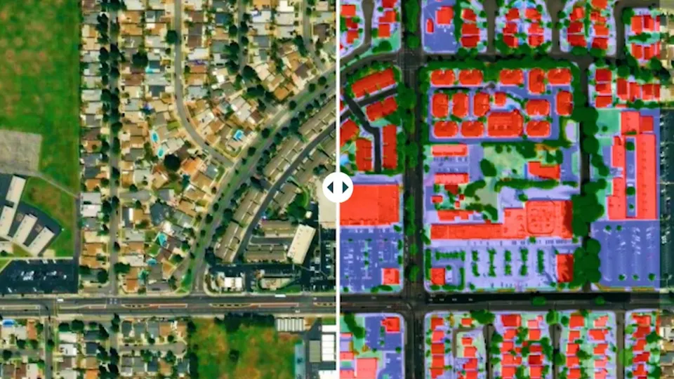
Using location-based insights, cities can manage resources more effectively and respond to changing conditions with greater accuracy. For example, mapping traffic patterns allows for better signal coordination, while spatial analysis of service demand improves waste collection efficiency.
Agriculture Driven by Spatial Precision
Within modern agriculture, decision-making has moved far beyond traditional observation. Farmers and agricultural systems now rely on spatial data to understand how different sections of land behave under varying conditions. Soil composition, moisture levels, and crop health can differ significantly across even small areas, making uniform treatment inefficient and often ineffective.
Geospatial tools allow these variations to be mapped and analyzed with accuracy. Irrigation systems can be adjusted based on specific zones rather than applied broadly. Planting patterns can be aligned with soil conditions, and harvesting schedules can reflect crop readiness across different sections.
Climate Modeling with Spatial Data
Understanding climate patterns requires more than isolated measurements. It depends on observing how environmental factors interact across regions and over time. Temperature swings, rainfall distribution, and atmospheric changes all carry spatial dimensions that influence long-term trends.
Geospatial data provides the structure needed to analyze these interactions. By mapping climate variables across large areas, researchers can identify patterns that inform predictive models. These models help anticipate changes in weather behavior, assess potential risks, and guide planning decisions in sectors such as agriculture, infrastructure, and energy.
Infrastructure Development Through Terrain Analysis
Large-scale development projects require a clear understanding of the land before construction begins. Terrain conditions, elevation changes, and underlying geological features all influence how structures can be built and maintained. Without accurate spatial insight, these factors can introduce risks that affect both safety and long-term performance.
Geospatial analysis allows planners to evaluate land conditions in detail. Mapping elevation, slope, and soil stability helps guide decisions on site selection and design. Potential challenges can be identified early, reducing the likelihood of costly adjustments later in the project.
Geospatial thinking continues to impact how complex challenges are approached across multiple sectors. By connecting data to location, it supports more accurate analysis and decision-making. Systems become more responsive, planning becomes more precise, and outcomes align more closely with real-world conditions.